

(2013)

The experiment of 360-degree Panorama Tripod Head or usually also called Panohead started in 2013 as a documentation method on a big collaboration environmental monitoring project called The Jogja River Project – 2013.
The idea of documentation methods is to make an interactive picture of the river’s environmental condition in a 360-degree view to make the river condition easier to understand. Instead of buying the 360-degree Panohead tool that is very expensive and hard to find in a common camera store, Joan Prahara Bumi and I as the member of the visual documentation team try to develop our own Panohead as an extension tool to be mounted on the tripod head.
The very first autodidact attempt is just a super simple tool, which was designed with an aluminium plate 3 cm wide and 3 mm thick. This tool is used to adjust the camera in the “No-Parallax” position when attaching to the camera tripod, even though we doing it with super less knowledge about the “No-Parallax” position itself. This tool is made based on as far as we know that the nodal point of the “No-Parallax” position is at the front lens centre, which was made ONLY for a 50mm lens with Nikon D80 and Nikon D90. Sincerely, the length between the Nodal point on the tripod circular axle and the camera’s body connector is about 10 cm.


The prototype, as a result, had little few changes to the aluminium width which became only 2 cm. Besides that, we made small changes by adding rubber to make the connection between the aluminium plate and the camera’s body more stiff and fit, which was also useful as the camera’s body protection from scratch that could happen because of metal friction.
Furthermore, although this prototype was very simple, it’s already been used to make a panorama picture as part of the Jogja River Project that was held during 2013 – 2014.


All of the pictures that were made with the first version of the 360-degree Panohead can be seen as part of the information on water monitoring interactive map of The Jogja River Project.

Sincerely, this experiment begins with the lack of knowledge and false understanding about the mechanical movement to maintain the nodal point and decreased the treats of parallax condition. It all brought a lot of notes to develop a better tool for the next version.
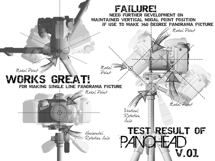
This version is working perfectly to maintain the nodal point only on horizontal movement, which is making a series of photos for panorama pictures in one line or a single row. However, it failed to maintain the nodal point when the process of making a bigger panorama picture, which had to make upper and under rows from the first row of the photo series. It happens because this V.01 prototype doesn’t have its own vertical rotation mechanism and depends on tripod vertical rotation, which was made each of the photo series in a single row has its own nodal point.

You must be logged in to post a comment.